intrastate/interstate
My Ideas for New Highways in NC
intrastate/interstate
|
I-48 |
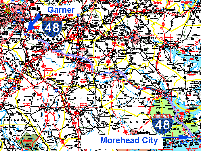 I-48 could go from Garner, NC to the coast at Morehead City, NC. Some of the route is already up to interstate highway standards. The route has been proposed as a freeway all the way to the coast anyhow, but as US 70. The problem with that is at each city or town that 70 bypasses, there would be a business and bypass route. (In one area there is also an alternate route.) This could be confusing to travelers, especially at night or in adverse conditions. Having an intrastate highway as the main route with US 70 through cities and towns would make it easier to follow the route. The different highway number plus the visually different intrastate highway shield would make the route obvious. This would provide better travel into or around each municipality. Sections of the route is already a freeway, and the Garner bypass set to open this year (2008). Havelock and Goldsboro bypasses are in the works too. A few remaining sections are unofficially proposed as freeway segments. I-40 to Wilmington has made tourism much larger in the coastal area near there. I-48 would help the central coastal area of the state compete. I-48 would also provide improved access for two military bases, and the state port at Morehead City. I-48 is an idea that could provide better transportation to these areas. The route that I-48 could follow would include bypasses around Clayton, New Bern, and Selma as well as the proposed bypasses around Havelock and Kinston. US 70 could be returned to the business routes through these towns and cities and simply be US 70 (no business or alternate designation). The route (from west to east) would start at I-40 near Clayton (presently the soon to open US 70 bypass). Between Clayton and Smithfield the highway would need to be improved to Selma. At Selma I-48 could take the present Bypass US 70 route. From Selma to the proposed Goldsboro bypass is another section that would need to be improved or bypassed. At Goldsboro I-48 would take the proposed bypass, and US 70 would remain through town. From Goldsboro to the La Grange bypass is another segment that would need to be improved or replaced. At La Grange I-48 could follow the freeway bypass around the town. Another gap from La Grange to the proposed bypass around Kinston would need improvements or replacement. Then I-48 could take the present US 70 freeway to the New Bern bypass. US 70 could be moved back to its previous route through Cove City and downtown New Bern. From New Bern to the proposed Havelock bypass it's possible that the highway could be converted into a freeway. US 70 and I-48 would follow the same route on this segment. At the proposed bypass around Havelock US 70 could remain the route through town, and I-48 could take the bypass. A new section of I-48 freeway would have to bypass Newport and connect to US 70 in Morehead City. US 70A (alternate) from Princeton to Selma could also be replace by NC 39 (which presently dead ends in Selma). The present US 70 route through Selma that connects to I-95 and US 301 could be a business route I-48 (identified by green shield signage, instead of the standard red, white and blue interstate shield). At present US 70, Business US 70, and US 70A (alternate) all have the same color (white with black lettering) signs. It can be very confusing for travellers. |
I-52 |
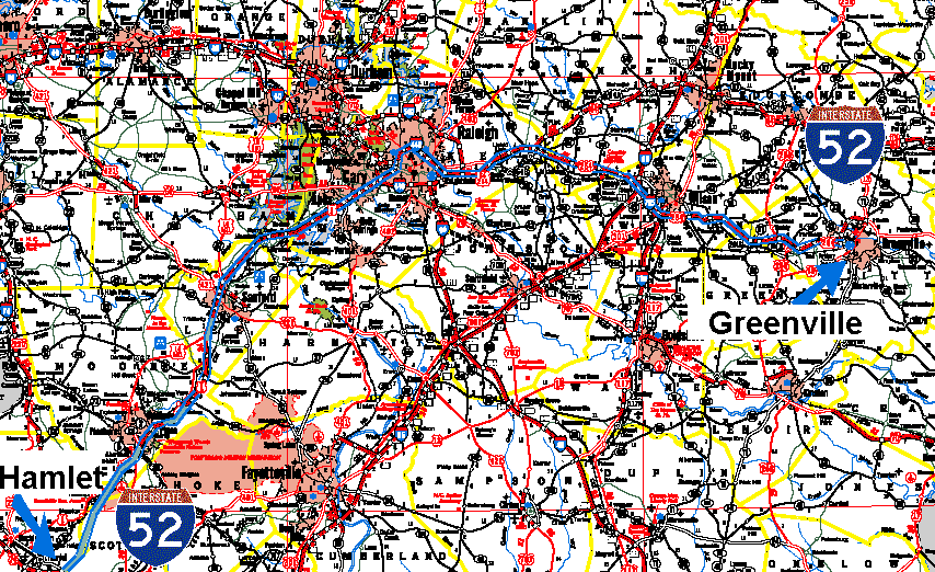 I-52 could go from Greenville, NC to Hamlet. Most of the route is already a freeway to interstate highway standards. Presently it's a confusing route with US highways having business, bypass, and alternate routes near towns or cities. I-52 could simplify the drive. The different highway number plus the interstate verses US highway shield markers would make the routes easier to follow. It could also provide the rapidly growing Greenville area with a direct interstate highway connection. The route (west to east) could start at future I-74 near Hamlet, NC, and replace or follow US 1 towards Raleigh. At Raleigh I-52 could replace I-440 to the present US 64/264 bypass. It could replace the Bypass 264 around Knightdale. From Zebulon to Greenville I-52 could replace US 264, and US 264 could return to the old route, now identified as Alternate 264. |
I-54 |
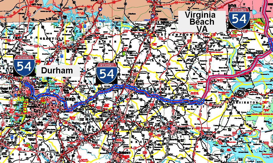 I-54 could replace confusing bypass and business routes of US 64 as well as replacing NC 147 in and near Durham. The route would encourage economic developement in the depressed northeastern section of the state, as well as give travelers a second well marked route from Research Triangle Park.. It could also give the Norfolk metropolitan area its first interstate highway access route to the south. The I-54 route (from west to east) would replace existing NC 147 on the Durham Freeway from I-85 to I-40. At I-40 the new highway could follow for a few miles to the Outer Loop (presently I-540). I-54 could replace I-540 in the northern suburban areas of Raleigh. This could allow the proposed southern section of I-540 to be a simple east-west route instead of a confusing loop with "inner" and "outer" designations, or sections that change through every compass point as you travel along the route. From the present Bypass US 64/264 interchange, I-54 could replace the US 64 Bypass route. US 64 could be moved onto the present business or alternate routes with I-54 taking over the freeway route. This could be done all the way from near Raleigh and Knightdale to near Williamston. At Williamston I-54 would follow roughly the route of US 17. A new freeway would have to be built to replace much of the route, although some sections may be able to be upgraded. The bypass around Elizabeth City could be part of the I-54 route, and US 17 could follow the present US 17 business route through the city. From there into Virginia is another section of US 17 that may have to be bypassed if the route cannot be upgraded to a freeway. In Virginia I-54 could be routed onto I-64 to the Virginia Beach Expressway. The present I-264 could be changed to I-54 into Virginia Beach. In the Tidewater region every interstate seems to have 64 in its number, so having a different route number would make it easier for tourist to find the correct route to Virginia Beach. It would also be a main freeway instead of a mere spur going into the city. |
| |
| All contents on this page, images, and HTML
code Copyright © 2008 Robert S. Bodnar |